
Walk a Kahului Street Directory
A reliable Kahului address search begins with the Real Property Assessment record, not a guessed occupant list. The parcel card gives a Tax Map Key, or TMK, plus the situs address and assessed owner. The TMK is the durable join between a street address, County maps, permits, ownership-history books, and recorded land documents. It is stronger than a postal label when spelling, locality, or street numbering has shifted. The assessed owner still is not proof of every person living at the address, so the result should be labeled as ownership evidence.
- Enter the location address in the Maui Real Property Tax search. Record the TMK, situs line, assessed owner, owner mailing address, and date of the assessment data.
- Open the County GIS viewer and locate the same TMK. Pan along the named road to see adjoining parcel shapes and map context.
- Carry the TMK into the County Public Documents searches. Check permits, plans, parcel information, field books, and ownership-history links.
- Search the Bureau of Conveyances by owner name, TMK, document number, or recording date. Read each grantor and grantee role before extending the chain.
- For a dated household clue, consult telephone or Polk volumes through a library. A listing supports presence near its publication date, not current occupancy.
This flow keeps the Kahului street directory grounded in official fields. If the address fails, try the TMK, owner surname, an older locality label, or a permit number. Preserve both successful and failed searches with their dates.
Search Kahului Property Fields
The Maui Real Property Tax website is the main address-to-owner route. County guidance documents six modes, though the live qPublic controls were blocked during research. Use only the modes the County confirms, and do not invent a ZIP filter or assume each field is shown on every result.
| Search mode | Best use | Result caution |
|---|---|---|
| Location address | Start a street directory search | May require spelling or locality variants |
| TMK or parcel | Join maps, permits, and deeds | Keep the full County format |
| Owner name | Find other assessed parcels | Not proof of occupancy |
| Map | Browse parcel context | Map layers have different dates |
| Sales search or list | Locate assessed sale references | Confirm the recorded instrument |
A parcel card may include the TMK, situs and mailing addresses, owner names, land class, assessed values, exemptions, sale references, sketches, and links to permits or tax maps. Cite the file date because Maui County also publishes raw extracts that change over time.
Kahului Address Fields Differ
Situs address means the physical location of the parcel. The owner mailing address is where assessment notices go. It may be a post office box, an agent, a trust, or a place outside Kahului. A home-exemption flag can support a time-bound owner-occupancy claim, but it does not name all household members.
- Parcel
- A mapped unit of land identified by a TMK.
- Situs address
- The County's physical-location field for the parcel.
- Plat
- A recorded map or plan showing land divisions.
- Criss-cross directory
- A directory arranged by address or phone number rather than surname.
For every by-address search, save situs and mailing values in separate columns. That small choice prevents a remote mailing address from becoming a false residence claim.
Note: An assessed owner, mailing recipient, deed party, phone subscriber, and resident are distinct roles that may belong to different people.
Map Kahului Streets by Parcel
The County of Maui combined GIS viewer helps place a parcel within Kahului's street grid. Search or pan to an address, switch on parcel and planning layers, click the parcel, and follow the TMK report link. The viewer can show parcel geometry, adjacency, zoning or district context, community plans, shoreline and flood layers, and historic map links. It is a discovery map, not an ownership certificate.
Layer dates vary. Confirm the assessed owner in RPA and a legal transfer through the Bureau of Conveyances. When a street label fails, parcel geometry and the TMK can keep the trail intact. GIS staff in Wailuku also provide appointment-based help by phone at 808-270-7735.
Kahului Permits Follow the TMK
The All Applications TMK Search accepts the County's 13-digit TMK style without dashes and allows a wildcard. The same public-document system links permits, plans, projects, subdivisions, as-builts, planning files, real-property field books, ownership histories, and map folders. Large PDFs may take up to 20 minutes, and the County warns that historic or recent data can be missing.
The search screen below belongs to Maui County. It shows the official TMK route used to connect a Kahului street address with public applications.
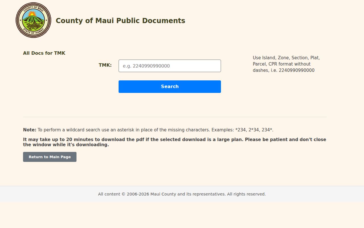
The captured form confirms that the parcel key, not a broad resident query, is the core lookup. Save each permit number and department so a missing PDF can be requested from the right office.
Kahului Street Records Compared
No one record serves as a complete street directory. Maui County assessment, GIS, permit, deed, voter, and library sources have different dates and access rules. Join them by address and TMK, then state exactly what each result supports.
| Record Set | Keeper | What It Shows | Access |
|---|---|---|---|
| Property assessment | Maui County RPA | Owner, situs, mailing address, TMK, values | Online, extracts, office or phone |
| GIS parcel map | Maui County GIS | Parcels, adjacency, layers and map context | Free viewer; appointment help |
| Deeds and liens | Hawaiʻi Bureau of Conveyances | Parties, instrument, date, TMK and legal description | 1976 forward online; older by room or writing |
| Voter data | Maui Elections Division | Public name, district or precinct, status | Purpose-based application; restricted fields |
| Permits and plans | Maui Public Documents and MAPPS | Address, TMK, permit, plan and project links | Online; department fallback |
The parcel search screenshot comes from Maui County's Parcel Information Search, which accepts TMK, permit type, permit number, address, city, and owner name.
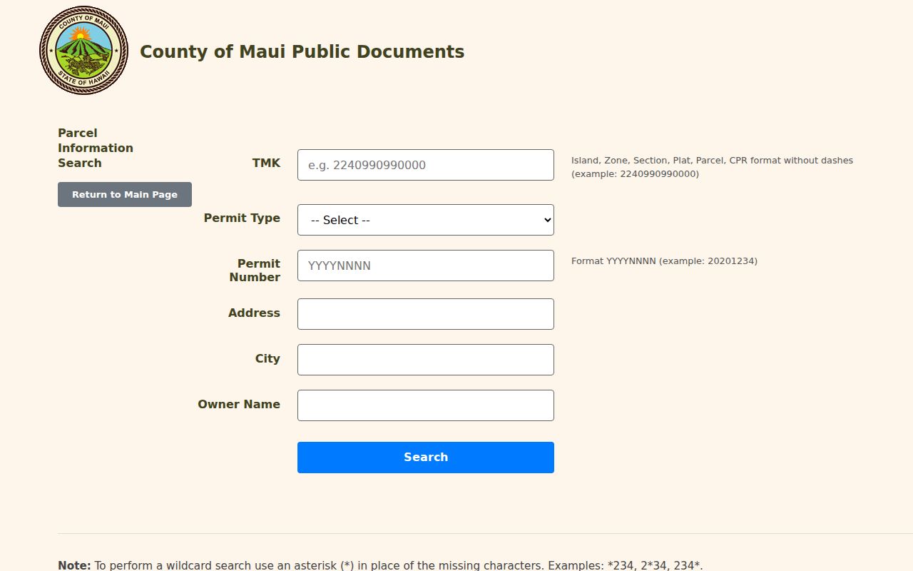
These fields let a street search move from an address to a known permit or owner, while the TMK remains the cleanest join across County systems.
Trace Kahului Deeds by Address
Hawaiʻi records land statewide through the Bureau of Conveyances Document Search, not a Maui County recorder. The modern index can search grantor, grantee, document number, TMK, Transfer Certificate of Title, and recording date. A grantor transfers an interest; a grantee receives it. Documents from 1976 forward have an online route, while older records require the Honolulu reference room or a written request.
Preview images are watermarked until purchase. Published costs are $1 per page online, while pre-1976 written research is $35 per document plus a $10 processing charge. Certified requests take about seven to ten business days. BOC records reach back to 1845, so a street directory trail can continue beyond the modern search if the legal description and party names are carried into the older channel.
Note: A deed proves a recorded transaction or interest, not that every named party lived at the Kahului situs address.
Kahului Street Names Need Context
Kahului is a Census-designated place, not an incorporated city with its own recorder. USPS delivery labels, Census boundaries, and County situs fields answer different questions. Historical sources may also use Wailuku, Puʻunēnē or Puunene, Spreckelsville, Paia, a plantation camp, initials, abbreviations, or spellings without Hawaiian diacritics. Keep the source's wording and add a normalized field only when County or postal evidence supports it.
Sanborn references for 1914, 1927, and 1945 offer a strong visual check on building footprints and street labels. RPA field and ownership-history books extend to 1987. No official, complete Kahului renumbering log was found, so never assign a guessed date to an address change. Search the old legal description, TMK, directory line, tax map, and neighboring landmarks instead.
When Kahului Portals Fall Short
Online gaps are common. Call RPA at 808-270-7722 or 808-270-7871 for assessment and map help. Printed tax maps can be ordered for $3 plus $1 postage. GIS provides appointment help in Wailuku, and MAPPS building-permit staff can be reached at 808-270-7250. For older deeds, send a targeted written BOC request or use its Honolulu reference room.
A Hawaiʻi Uniform Information Practices Act request can seek a specific existing County map, permit file, date range, TMK, or format through the Maui County records portal. It cannot require an office to create a new list of all residents along a street. Historical directory help belongs with Kahului Public Library, UH collections, Maui Historical Society, or the State Archives.
Kahului Street Directory Limits
There is no unrestricted public roster of every current occupant on a Kahului block. Assessment records identify owners, not all residents. County GIS shows parcels, not households. Voter law makes only full name, district or precinct designation, and voter status public; other registration details are confidential except for approved election or government purposes. Maui's full voter-file application requires a stated purpose, an affidavit, and a published $100 charge plus postage.
Modern utility customer data and driver address data are not open street lists. The Hawaiʻi Address Confidentiality Program can substitute a protected mailing address for qualifying survivors. A missing or substituted address is therefore not evidence that someone has left Kahului.
Lawful use. Use Kahului street records only for lawful personal, family, property, or civic research. Never use an address trail to stalk, harass, intimidate, or harm anyone.
For historical household work, the Kahului city directory collections explain the dated Polk and telephone volumes. Current address research should always preserve uncertainty and verify each record with its custodian.
Kahului Street Directory Fallbacks
Online absence does not end a by-address search. The Real Property Assessment office in Kahului can explain a TMK, tax map, parcel history, or public extract. Development Services Administration can help with permits tied to an address, while Planning handles its own case files. For a document missing from the County index, note the street, TMK, record category, and date range before contacting the department. A UIPA request should seek an existing permit, field book, map folder, or ownership-history page, not ask staff to compile a new street roster.
Land records have a separate fallback. BOC documents from 1976 forward are indexed online, but older deeds require the Honolulu reference room or a written request. Send the grantor or grantee name, approximate recording date, TMK or legal description, and any book, page, or document number already found. The Hawaiʻi State Archives, Kahului Public Library, Maui Historical Society, and FamilySearch collection descriptions can bridge older maps and name indexes. Keep the address exactly as printed before trying a modern spelling.
Street results also change with time. Maui assessment values are set for an annual cycle, MAPPS has a 2022 launch boundary and later upgrades, and deeds have their own recording date. Save the access date, portal name, and result key. When two records disagree, prefer the record made closest to the event and verify the discrepancy with the custodian.
Date Every Kahului Street Result
A street directory finding is only as current as its source. Write down the assessment year, recording date, permit status, directory year, and day accessed. That short timeline prevents an old owner, mailing address, or permit contact from being mistaken for a current household.